
Data
This page lists FIU EnviStor's environmental datasets and their FAIR (Findable, Accessible, Interoperable, Reusable) publication status. Every number below is checked against the live Dataverse record — not copied from a slide or a report. See how the platform and its human-in-the-loop agentic-AI workflow behind these numbers work on the Home page and in the PEARC 2026 paper ↗.
Last verified: 2026-07-25 How we verify this →
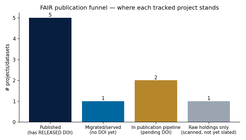
5
Published projects
with a RELEASED Dataverse DOI
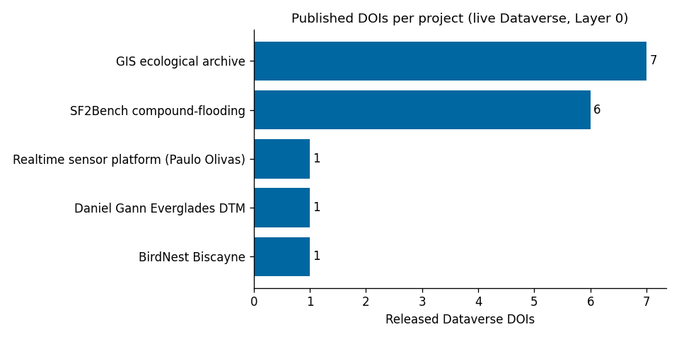
16
Released DOIs
across those 5 projects
3
In the publication pipeline
real data, DOI pending
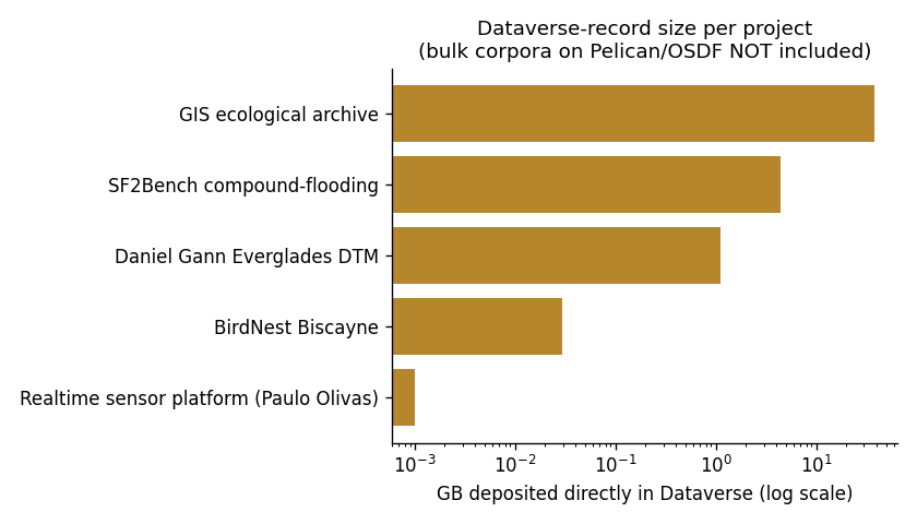
43.6 GB
Data volume in Dataverse
excludes bulk corpora hosted on Pelican/OSDF (e.g. BirdNest’s 113 GB image set)
Data at a Glance
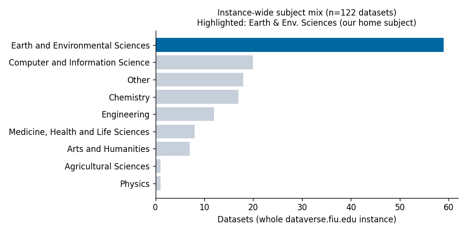
How our published datasets stack up — by project, by size, by publication stage — and how that compares to the rest of FIU's Dataverse over time. We're not drawing conclusions here; the charts just show what's there.
 🔍 Click to enlarge
 🔍 Click to enlarge
 🔍 Click to enlarge
 🔍 Click to enlarge
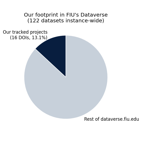 🔍 Click to enlarge
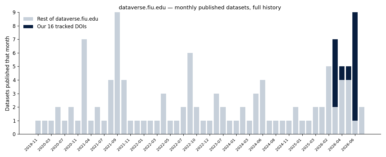 🔍 Click to enlarge
Spatial coverage
Where the data underlying these DOIs comes from — point/region markers, not exact georeferenced footprints. Click a marker to jump to that project's card below.
Published
Every project below has at least one Dataverse record with the status RELEASED, confirmed live against the Dataverse API (not a report describing it).
BirdNest Biscayne ↗
✅ VerifiedNational Park Service · FIU GIS Center
- · 15,759 aerial images
- · 161,744 AI-assisted annotations
- · 117 helicopter surveys (2010–2024)
Dataverse record (~30 MB) holds the model/metadata package; the full 113 GB image corpus is hosted on Pelican/OSDF.
GIS Ecological Data Archive ↗
✅ VerifiedFIU GIS Center
- · 844 geospatial layers
- · 7 Dataverse DOIs (1 master + 6 regional)
- · ~38 GB in Dataverse
Legacy FIU GIS Center geoportal, migrated to the EnviStor FAIR pipeline (2025–2026).
SF2Bench — Compound-Flooding Benchmark ↗
✅ VerifiedObey Research Group
- · 2,452 monitoring stations
- · 8,557 files, 1985–2024
- · ~4.4 GB in Dataverse
6 Dataverse DOIs (1 master + 5 station types: water, groundwater, gate, pump, rainfall), all RELEASED.
Everglades National Park DTM
✅ VerifiedDaniel Gann, Gann Spatial Ecology Lab
- · 1 bias-adjusted lidar-derived GeoTIFF
- · 2 m resolution
- · ~1.1 GB
The simplest end-to-end case: single file, single PI, fully FAIR-published with checksums.
Paulo Olivas, sensor PI
- · 5 instruments (PurpleAir ×3, Tempest, Pandora 256)
- · Air quality + atmospheric chemistry, growing daily
FIU Miami campus. A companion coastal-buoy pipeline is validated on test data and moving toward production with the NSF CREST Center for Aquatic Chemistry & Environment.
This work is described in more depth in "Exploring Robust Multi-Agent Workflows for Environmental Data Management" (PEARC 2026) ↗ and "A Scalable Framework for Heterogeneous Environmental Data Management Using Smart Data Pipeline" (PEARC 2025) ↗ — see the full list on Publications.
In progress
Real data, real pipelines — just not a released Dataverse DOI yet. No external link, because there's nothing published to link to.
Historic Aerial Imagery Archive ↗
🔶 In progressFIU GIS Center
4,025 files · ~157 GB (1924–1954)
Migrated + already served on maps.fiu.edu — DOI not yet requested
LOCA2-CMIP6 Florida (climate projections)
🔶 In progressObey Research Group
~3.1 TB, full scope
Sequencing into 3 variable-specific Dataverse records (precipitation → Tmax → Tmin); first pilot staged
Global Sea Level Change
🔶 In progressObey Research Group
~1.2 TB · GTSM/ERA5 reanalysis + CMIP6 projections
Planned as 1 master record + product-specific sub-records
Coastal Buoy Pilot
🔶 In progressObey Research Group · NSF CREST Center for Aquatic Chemistry & Environment
Pipeline mechanics validated on real test data
Formal onboarding of live buoy readings pending CREST Center collaboration
The Obey Research Group's two in-progress climate products above are part of a 54.7 TB / 369,857-file NAS holdings scan — most of that scan is raw storage, not yet slated for publication. See the full project list on Projects & Data Showcase.
How we verify these numbers
Every number on this page traces to one of these sources, checked in order of strength (strongest first):
- Live Dataverse record — the actual RELEASED dataset, queried directly via the Dataverse API. Outranks any doc, task, or report describing it.
- Dataverse instance & search metrics — FIU's own Make Data Count / COUNTER-compliant metrics API and search index, for platform-wide context (total datasets, publication dates, subject mix).
- Project & task records — structured facts from the platform's project management system.
- Curated knowledge base & message history — lowest-reliability tier; treated as "someone reported this," re-confirmed against a live system before being shown here.
The charts above come from fair_publication_stats.ipynb,
a notebook that queries the live Dataverse record and Dataverse's own metrics/search APIs
directly, so they stay in sync with the same numbers above. This page is regenerated on
demand (not on a fixed schedule) whenever a project publishes something new. See
AI Governance & Data Access
for how the underlying agentic publication workflow is reviewed and gated by named humans
before anything goes public.